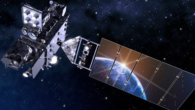
Geostationary satellites, like NOAA’s Geostationary Operational Environmental Satellite (GOES), remain fixed over a specific region, constantly monitoring for new fires and sending updates every few minutes. This fixed position means areas prone to wildfires are constantly watched and allow us to more easily answer questions like “Where are the wildfires in Canada?” or “Where did the LA fires start?”. (GOES-R rendering courtesy NASA)
Wildfires always start small but within minutes, they can grow and transform rapidly into catastrophic events like the devastating, destructive fires we all too often see in the news. Unfortunately, firefighters oftentimes don’t even know a fire has started until an emergency call comes in from someone on the ground. By then, the blaze can already be spiraling out of control, especially in remote areas where weather and challenging geography prevent quick detection and response. Whether deep in forests or close to communities, wildfires can quickly threaten ecosystems and lives.
Around the world, wildfires are increasing in intensity, frequency, and destruction. While fire is an essential, natural process for ecosystems, a small percentage of fires become extreme wildfire events which drive over 80% of total associated fire damages. Even with today's advanced technology, the timing of getting data in the right hands can mean the difference between a small, manageable wildfire and a devastating disaster like the 2025 LA wildfires. The gap between the first spark and the alert reaching emergency responders is critical. Every second counts in wildfire detection, and the longer it takes to spot an incipient fire that poses a risk, the more devastating the outcome. The question isn’t just whether we can detect wildfires – it’s how early and accurately we can identify potentially extreme wildfire events before they spiral out of control.
THE BENEFITS AND CHALLENGES OF SPACE-BASED WILDFIRE DETECTION
Space-based satellite detection offers powerful tools for monitoring wildfires and is transforming how we detect and respond to fires. Satellites can offer a bird’s-eye view of Earth that allows us to monitor vast landscapes in real-time. Yet significant challenges remain as they are not keeping up with the mounting challenges of accelerating wildfires. To truly revolutionize wildfire detection, a few key challenges facing today’s space-based wildfire detection systems must be addressed.
- Delays in detection Current best-in-class space-based satellites can take up to 90 minutes to make their orbit, downlink and process their data, leading to lag times between a wildfire starting and a fire manager receiving an alert. During this delay, a fire can grow exponentially, making it harder to control by the time help arrives.
- Gaps in coverage: Two types of satellites are most commonly used but have their limitations in coverage. Geostationary Earth Orbit (GEO) satellites are regionally limited and cover only a single area, and Low Earth Orbit (LEO) satellites provide global coverage but take longer to deliver updated data, which limits their ability to provide timely alerts for fast-growing fires.
- Low resolution: The existing satellite technologies have inherent limitations for identifying incipient fires. GEO satellites have persistent coverage with low resolution (less than 1000m), whereas LEO satellites have infrequent coverage with higher resolution (less than 100m). Neither has the precise resolution desired to identify incipient fires in an exact location, which often means these early stage fires grow undetected.
- Natural obstacles: Cloud cover, smoke, and challenging geographical features often interfere with wildfire detection or cause systems to miss early wildfires entirely.
- False positives: Heat signatures, known as ‘hotspots,’ are not always wildfires. Hotspots can come from solar panels, hot springs, and other anomalies that can result in false positives. These false alarms can waste resources and divert attention from real fires, slowing response times.
- Lack of actionable insights: While current satellite systems can detect heat anomalies, they often fail to provide the detailed, actionable insights fire managers need to make informed decisions quickly. Information like the fire’s intensity, the direction of spread, and size is often delayed or insufficient, making it difficult for fire managers to allocate resources effectively or strategize their response in real-time.
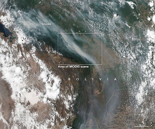
Here, cloud cover and smoke from a wildfire in Bolivia mix together in a MODIS satellite image. As wildfires worsen from the effects of climate change and threaten ecosystems that are not adapted to natural wildfires like tropical forests, solutions like those from XPRIZE Wildfire teams are becoming more urgently needed to protect nature and communities. © NASA
HOW XPRIZE WILDFIRE WILL IMPROVE SPACE-BASED WILDFIRE DETECTION
Teams in the XPRIZE Wildfire Space-based Detection track are addressing the challenges identified by XPRIZE to be the greatest barriers to satellite detection by developing solutions that deliver more timely, accurate, and actionable data. The testing criteria for this track are rigorous: solutions must be able to detect active wildfires with high accuracy and precision.
- Faster data: XPRIZE Wildfire teams must reduce the time it takes to detect fires to just one minute and provide detailed, actionable data to fire managers within 10 minutes . This means shrinking detection delays and improving the flow of real-time information to firefighters.
- Overcome obstacles: Teams are using cutting-edge approaches to “see” through obstacles like clouds and smoke and overcome the challenges posed by difficult terrain. Their solutions must work reliably in all conditions to ensure fires are spotted early, no matter the environment.
- Reduce false positives: A major focus of the competition is reducing the rate of false positives, which will be tested rigorously throughout the competition rounds. Teams must demonstrate that their systems can accurately distinguish between true wildfire hotspots and other harmless heat sources like solar panels, ensuring resources are directed only to real threats.
- Real-Time, Actionable Intelligence: Beyond detection, XPRIZE Wildfire teams must ensure that the data they provide is immediately usable by fire managers. This means giving firefighters all the critical details—such as fire location, size, and behavior—so they can deploy the right resources and strategies without delay.
Innovative solutions are more critical than ever as destructive wildfires continue to threaten communities, ecosystems, and livelihoods worldwide. The XPRIZE Wildfire competition is supporting and shining a spotlight on cutting-edge technologies that have the potential to revolutionize wildfire detection and response. By pushing the boundaries of space-based detection, these teams are taking us one step closer to faster, more effective wildfire management.
Stay tuned as the competition unfolds on an aggressive timeline where solutions will be put to the test over the course of 2025. Discover how these groundbreaking solutions will help us face the growing threat of wildfires. Follow XPRIZE Wildfire to witness the future of fire detection in action and see how these innovations could transform how we protect both people and nature.
THE AUTHOR